|
|
 |
Flood Forecasting and Warning in Bangladesh
Introduction
Decision-makers worldwide face a difficult challenge in developing an effective response to the threat of water-induced disasters. In Bangladesh, this task is more complex, not only because of the multitude of such disasters, but also because of the countrys vulnerable geography. Major parts of Bangladesh occupy the deltaic plain of the Ganges-Brahmaputra-Meghna river system. Bangladesh is criss-crossed by a labyrinth of rivers. As the country is located at the lowest reach of the fluvial system, and in the area affected by coastal surges, flood disasters of different types are frequent, including river, urban and tidal or storm surge flooding.
Flood Forecasting and Warning
Flood mitigation options planned and implemented in the past have been controversial. Mainly structural measures, such as embankments, were used. However, since it is neither possible nor desirable to control floods completely, a new approach to flood management based on information technology has been recognized as the most effective measure to reduce flood damage.
Flood management includes flood forecasting and advance warning. Flood forecasting is the prediction of water levels, areas and depths of flooding in rivers and flood plains. Flood warning is the preparation of forecasts in a meaningful format which can be numerical or visual. In order to be effective, the warning has to be disseminated to the media for broadcast to concerned organizations who are prepared to provide relief, and to vulnerable communities.
From the early 1990s, a flood forecasting and warning system based on an advanced hydraulic model has been applied in Bangladesh. However, the system has been limited to the forecasting of water levels in the major rivers. These forecasts have not been easily understood nor used by the rural population, as the dissemination system has been inadequate. During the last five years, an enhanced forecasting system has been developed which includes depth-area inundation forecasting. In order to meet the requirements of the end-users of forecasts and warnings, a new dissemination system has also been developed. This includes a suite of phased warning messages that introduces early notification to other agencies and additional phases of warning messages as the severity and impact of flooding increases. The new flood forecasting system, MIKE11, has been integrated in a GIS environment and provides a powerful tool for real-time flood forecasting and flood warning.
The Dissemination System
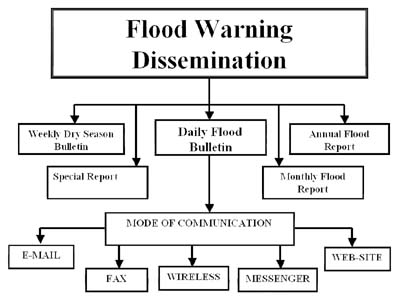
The enhanced flood forecasting and warning services include a component for the improvement of the dissemination system, which supports a programme for public awareness and understanding of the forecast and warning information and the benefits to be derived from it. Improved dissemination (see the figure) has been implemented as a new National Flood Forecasting and Response System comprising a number of elements:
- A user-friendly management system for display and dissemination of flood information and flood warnings.
- Increased use of Bangladesh radio and television to broadcast flood warning messages.
- A suite of phased warning messages that introduce early notification to other agencies and additional phases of warning messages as the severity and impact of flooding increases.
- Warning messages designed to communicate effectively to members of the community at risk by using simple messages in local languages.
- Warning messages providing information on the impacts of flooding.
- A structured classification of flood warning and information products which separates information and forecasts from warning messages, and supplies key information to decision-makers in a concise form.
- Flood marker posts at river water level stations showing, by means of colored bands, the likely level of flooding. The messages will advise which color and band of severity are being warned.
- Compatibility and ultimately integration with Emergency Standing Orders for Disaster.
- Education and publicity material to raise flood awareness at community level.
- A Bangladesh Flood Warning Manual, which establishes the basic philosophy and principles of flood warning in order to develop increased awareness and participation by other agencies and community leaders.
Daily Procedures at the Flood Forecasting and Warning Centre
Every morning during the monsoon season, real-time data are collected from more than 60 water level and rainfall stations throughout the country. Afterwards the real-time data are carefully checked and processed by means of the MIKE11 Flood Watch system. Additional information such as weather forecasts, satellite images and flood information from India is interpreted before the final data input to MIKE11 is made. Water level forecasts are issued for the next 24, 48 and 72 hours for 40 locations. A typical simulation applying the MIKE11 system takes 30 minutes. In addition, the MIKE11 GIS module is used to produce depth-area inundation flood maps.
Formulation and Dissemination of Flood Warnings
The recorded and forecast water levels are reported in the daily official Flood Forecasting Bulletin published by the Flood Forecasting and Warning Centre and distributed to all concerned agencies. Separate flood warning messages are prepared for areas where the flood situation requires warnings. The flood warnings are normally issued when the water levels are forecast to rise above danger level. These warnings are then transmitted to relevant authorities, e.g. the Disaster Management Bureau, national radio and television, and the Prime Ministers office.
Guna N Paudyal is with the Flood Forecasting and Warning Centre, Dhaka, Bangladesh, and can be reached at
gnp@dhi.dk
|