|
PHILIPPINES
COUNTRY
PROFILE
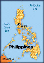
Philippines got its name from the Spanish King Philip II. It underwent years
of political turmoil first under the Spaniards and then the Americans, till it
finally gained independence in 1946. It is an archipelago consisting of 7100
islands located between the South China Sea and the Pacific Ocean and on the
Southeast Asian continental shelf. It lies on the western rim of the pacific
and is part of the circum-pacific seismic belt. It stretches more than 1800 kms
from north to south and 1046 km from east to west at its widest extent.
Because of its geographical location, Philippines is exposed to a variety of hazards ranging from typhoons, storms, floods, tsunamis, earthquakes, volcanic eruption, landslides and droughts.
Major Disasters
Typhoons: An annual average of 30 typhoons occur in the north-western pacific ocean of which 20 occur in Philippines alone causing immense damage to life and property. The typhoons occur mainly between July and November.
Storm Surges
The irregular coastlines and the numerous typhoons makes Philippines vulnerable to storm surges. High tides coinciding with a storm intensifies the surge. Factors contributing to the height of storm surges are a concave coastline that prevents the rising water from moving laterally, a fast moving storm that does not allow time for the water to spread and shallow coastal waters. Environmental degradations such as destruction of mangroves, coral reefs and other forms of natural breakwater, siltation of river deltas bays, and shore-line reclamation also increases the storm surge hazard.
Floods
Heavy rains accompanying typhoons usually cause extensive floods. Areas most prone to floods are Eastern Mindanao, Northern Samar, Central Luzon and Bicol region. Flooding in Metro manila occurs because of its low-lying area have inadequate drainage systems.
Volcanoes
Philippines has more than 200 volcanoes distributed along five volcanic belts. Of these at least 17 are considered active. The 5 most active and destructive are Mayon, Taal, Hibok-Hibok, Bulusan and Canlaon.
Earthquakes
Philippines lies between two of the world's major tectonic plates, the Pacific and Eurasian plates, The first moving north-west is pushing the Philippines sea plates at a rate of about 7 cm a year. The oceanic parts of the second are being reduced along the western side of Luzon and Mindanao at the rate of 3 cm a year.
Eight major and several minor earthquake generators have been identified in the Philippines archipelago. Between 1589 and 1983, there were 63 earthquakes which caused major destruction.
Tsunamis
Tsunamis have affected Philippines coastal areas up to more than 4 meters above sea level. The coastal areas of Mindanao facing the Celebes Sea are particularly vulnerable. From 1603 to 1975, earthquakes generated 27 tsunamis which affected coastal towns.
Landslides
The area around Baguio in Northern Luzon with an elevation of 1460 m is prone to landslides but other parts of Luzon and the rest of the archipelago are also vulnerable. Excessive rainfall frequently leads to landslides.
Droughts
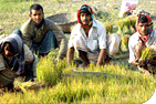
Droughts are not common in the Philippines. The most recent drought occurred in 1989 and resulted in damaging rice crops of about 326 million covering 31,587 hectares of rain-fed and irrigated lands.
Links
|