- About Us
- Publications
- ADPC Academy
-
MediaADPC'S NEWS
SERVIR-Mekong promotes the use of geospatial data for development in Lower Mekong SERVIR-Mekong promotes the use of geospatial data for development in Lower Mekong
17 Dec 2015
Bangkok, Thailand
Asian Disaster Preparedness Center has joined hands with the United States Agency for International Development (USAID) and the U.S. National Aeronautics and Space Administration (NASA) to implement SERVIR-Mekong, a five-year geospatial data for development program in the Lower Mekong Region. The program helps decision makers utilize publicly available satellite imagery and geospatial technologies for improved preparedness for natural disasters.
The Mekong River is critical to the biodiversity, livelihoods and food security of 240 million people living in Cambodia, Lao PDR, Myanmar, Thailand and Vietnam. For years, scientists have voiced concern regarding the impact of extreme weather and climate change to the Mekong region and beyond, affecting the ability of communities to adapt to a volatile environment.
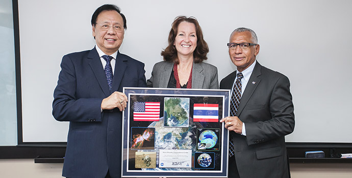
NASA Administrator Charles Bolden (right), USAID Regional Development Mission for Asia Director Beth Paige (center) and
Dr. Bhichit Rattakul, Special Advisor to ADPC launched the SERVIR-Mekong project in Bangkok on 31 August 2015.
(Photo: Phuriwat Photography)
As part of SERVIR-Mekong, ADPC with partners will support the region’s countries in making risk-informed decisions on water management, land-use planning, disaster risk reduction, infrastructure development, and natural resources management.
“For ADPC, SERVIR-Mekong is a unique effort. It expands the scope of the organization’s work from disaster risk reduction towards addressing the drivers of disaster vulnerability that are stemming from environmental management and climate change,” says Dr. Peeranan Towashiraporn, Director of ADPC.
Aiding disaster response
The United States has 16 earth observation satellites orbiting the globe bearing sensors that measure heights, temperatures, wind speeds, and other aspects of the environment – NASA currently manages 9.1 million gigabytes of this data. ADPC, USAID and NASA together with the SERVIR-Mekong consortium partners, including Spatial Informatics Group, Stockholm Environment Institute and Deltares, promotes the use of this publicly available satellite imagery to address pressing needs in the region.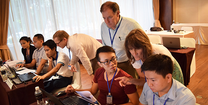
Researchers from the Lower Mekong countries are learning the latest tools for analyzing Landsat satellite data.
Other SERVIR hubs around the globe have previously provided critical data for countries responding to and recovering from disasters. During the Nepal Earthquake in April 2015, for example, the SERVIR-Himalaya hub and the SERVIR Coordination Office of NASA collated satellite imagery from different U.S. government agencies to provide targeted information about villages affected by the earthquake and subsequent landslides in remote mountain areas.
Listening to the needs of the regionDuring the first year of SERVIR-Mekong in 2015, ADPC conducted a comprehensive regional needs assessment to better understand the Lower Mekong countries’ geospatial capacities, including their ability to utilize satellite data and related products, and to perform geospatial analysis on the data. During the assessment, ADPC found that there is a need for comprehensive datasets on land-use, water, and the mapping of natural ecosystems.
“We will initially ensure the development of analytical and decision support tools for land-cover monitoring, early warning systems and disaster risk management for droughts and flooding, water resource management, and crop yield forecasting,” says Dr. David Ganz, ADPC’s Chief of Party for SERVIR-Mekong.
ADPC together with a consortium is developing several tools and systems to respond to the identified needs. These tools and their uses are the following:1) a flood extent mapping tool that derives information from publicly available satellite imagery and data;
2) a regional land-cover monitoring system that will utilize a uniform typology (classification system) to monitor land cover in the Lower Mekong Region;
3) a regional drought monitoring system that will provide local decision makers with seasonal forecasts and drought indices; and
4) a hydro-meteorological data service that marries data from satellites with on-the-ground measurements.
Raising capacities for geospatial analysis
The needs assessment also revealed a need for focused capacity building of government institutions and non-governmental organizations in the Mekong region.“Training, research and collaboration with local universities are now underway in the five countries to enhance local technical capabilities to use the tools developed through SERVIR-Mekong. This is to ensure that the information they produce is utilized within national and local decision-making to reduce disaster risk, adapt to and mitigate climate change, and enhance environmental management,” stated Dr. Towashiraporn.
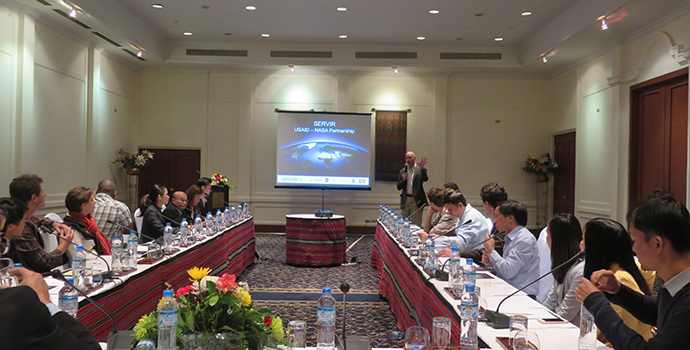
The SERVIR-Mekong team from USAID, ADPC and SIG lead discussions to identify gaps in planning tools useful for civil society organizations in Lao PDR.
In its latest capacity building effort, SERVIR-Mekong partnered with the U.S. Department of Interior’s International Technical Assistance Program and the multi-agency SilvaCarbon program to facilitate a training course focusing on understanding, accessing, and effectively using data from the Landsat Earth observation missions. The five-day training course was held in late October in Bangkok with instruction provided by remote sensing specialists from the U.S. Fish and Wildlife Service and U.S. Geological Survey.
The training focused on procedures and tools for mapping different land and water forms based on the Landsat satellite data that is freely available to the public. It also provided an opportunity to explore the use of Google Earth Engine as a free online service for accessing and running complex models and algorithms, as well as the Earth Explorer online portal to search for and download images. Read more on the training here.
About the program
To learn more about SERVIR-Mekong or get more information about the tools, satellite data, knowledge products and training announcements it provides, visit the site servir.apdc.net.
-