- About Us
- Publications
- ADPC Academy
-
MediaADPC'S NEWS
The view from space: a wider perspective of our changing planet The view from space: a wider perspective of our changing planet
22 Apr 2015
Bangkok, Thailand
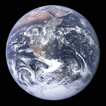
On December 7, 1972, with the sun at their backs astronauts of the Apollo 17 took the first photograph of the earth in its entirety. From 45,000 kilometers away, they described the earth resembling a marble.
After returning to earth the photograph soon became widespread, and today is speculated to be one of the most widely distributed images in human history. The sight of the whole earth fully illuminated resonated with people and became a symbol of the environmental movement.
For the first time people could see just how finite our planet and its resources really are. The iconic image became known as The Blue Marble.
A day to reflect
For Asian Disaster Preparedness Center (ADPC), this Earth Day is about appreciating the delicate Blue Marble we call home, and acknowledging how technology has evolved over the years.
Roughly 40 years after the iconic Blue Marble photograph, new tools and techniques give decision-makers more opportunities to understand, prepare for, and respond to dynamic and sometimes unpredictable conditions on earth including those related to climate change, forest conversion, and expanding urban areas.
In October 2014, the United States Agency for International Development (USAID) and the U.S. National Aeronautics and Space Administration (NASA) announced the launch of SERVIR Mekong, a five-year project that facilitates the use of satellite data to better predict and cope with the increasing occurrence of floods, droughts, and other negative effects of climate change in Asia’s Lower Mekong region.
With funding from USAID, ADPC serves as the SERVIR Mekong Hub, aiding government and other decision makers in Cambodia, Myanmar, Laos, Thailand and Vietnam in applying publically available satellite imagery, geospatial data and maps to make key decisions on issues such as water management, land-use planning, disaster risk reduction, infrastructure development and natural resource management.
The project is part of SERVIR Global, an initiative that combines satellite observations, ground-based data and forecast models to monitor and predict environmental changes and to improve response to natural disasters.
SERVIR uses space technology for the greater good and lets us view our planet in a different way, just as the Blue Marble image changed our perspective so many years ago. The difference is that today we can use space technology to protect the livelihoods of those that have so much to protect on the little Blue Marble we call home.
(Photo credit: Public Domain courtesy of Wikipedia)
A video describing SERVIR:
-